
Drones along with LiDAR technology have revolutionized the way archaeological sites are researched and understood. This powerful combination of technologies provides a much more detailed and accurate insight into the terrain and hidden structures, which has led to new archaeological discoveries and a deeper understanding of the historical heritage.
In this article we present a concrete case of using state-of-the-art drones and the best LiDAR systems on the market to scan an area, with the aim of detecting possible archaeological sites.

How drones are used in archaeology
The role of drones in archeology is extremely valuable and has grown significantly in recent years, providing significant opportunities for discovery, mapping and archaeological research.
Ways drones are used in archeology include:
- Aerial mapping and photography: Drones make it easy to photograph large but hard-to-reach areas, giving archaeologists detailed aerial perspectives of archaeological sites. This can be particularly useful in the context of preliminary site surveys and assessments, identifying hidden or underground archaeological features.
- Detailed Documentation and Analysis: Drones find it easy to fly at varying altitudes and angles, allowing detailed documentation of structures and archaeological sites. Captured images can be used to create 3D models, maps and digital reconstructions, giving researchers complete and accessible perspectives from any angle.
- Identifying archaeological sites: Drone technology can help detect and identify archaeological sites buried or masked by vegetation. For example, infrared sensors can be used to detect subtle variations in vegetation, indicating the presence of structures or other archaeological features.
- Non-invasive surveys: The drone can be used to assess archaeological sites non-invasively, without requiring excavation or damaging the site. This reduces the risk of damage to artifacts and structures, while providing a global picture of the situation without disturbing the archaeological stratification.
- Monitoring and protecting sites: Drones find it easy to patrol and monitor archaeological sites, ensuring that they are protected from illegal activities, theft or vandalism. Aerial imagery can be used to detect changes or damage over time and implement appropriate protective measures.
- Drone-Assisted Excavations: During archaeological excavations, the drone can be used to quickly map and document the excavation area, helping archaeologists understand the context better and make more informed decisions throughout the excavation.
Overall, the drone can bring increased efficiency and a broader perspective to archaeological research, making it possible to make deeper discoveries and understandings about our past. However, it is important that the use of drones in archeology is carried out responsibly and with respect for cultural heritage, research ethics and local laws governing these technologies.

About the route and data
The targeted area includes areas in Timiș County, along a railway, the aim being the scanning of this railway line, on the route of which archaeological sites could be identified.
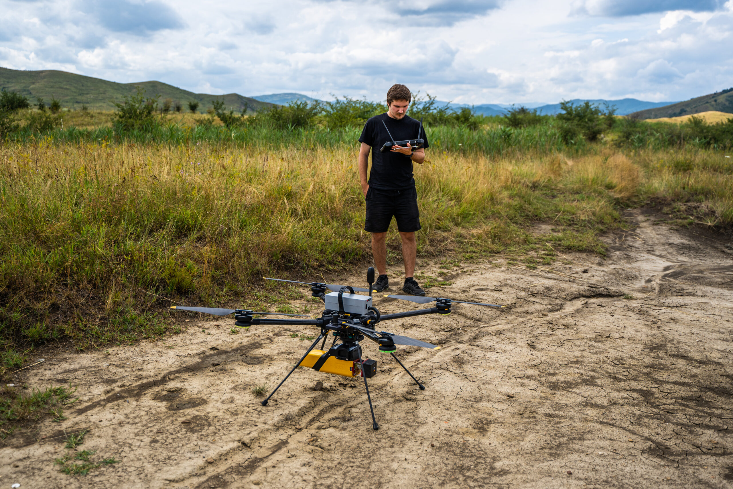
Hard-to-reach areas or areas with heavy vegetation are a challenge when it comes to terrain analysis. For these areas, LiDAR systems are the perfect choice because they allow research and observation of the terrain configuration, with the laser beams penetrating the vegetation. One such LiDAR system – the Qube 240 – was used together with the Trinity F90+ drone to scan a railway line. The model obtained was transformed into a digital model of the terrain and successfully compensated for the inability to carry out ground surveys.
The methodology consisted of first taking points for iBase. The points were established in places favorable to the landing of the drone: flat surfaces, without obstacles nearby. Afterwards, the movement to the established points took place, with the flight plan made in QBase and the flights were carried out with the Trinity F90+ drone and the LiDAR Qube240 payload.
The table below represents the flight missions performed for data collection and the quality parameters used. As can be seen, the point density varies with the cruise speed and is between 80 and 150 m2, the height at which the flights were made is 100 m, and the “area” areas have an overlap of 30% between them, the area of these areas varying from 90 ha to 171.7 ha.
| Area | Area type | Width | Overlap | Scan duration (min) | The height at which it flew | Corridor distance (km) | Total area flown (ha) | Point density (/m²) |
|---|---|---|---|---|---|---|---|---|
| 1 | area | – | 30 | 16 | 100 | – | 94,4 | 80-150 |
| 2 | area | – | 30 | 15 | 100 | – | 90 | 80-150 |
| 3 | area | – | 30 | 22 | 100 | – | 151,4 | 80-150 |
| 4 | area | – | 30 | 26 | 100 | – | 171,7 | 80-150 |
| 5 | coridor | 350 | 40 | 16 | 100 | 5,3 | 186,8 | 80-150 |
| 6 | area | – | 30 | 19 | 100 | – | 125,8 | 80-150 |
| 7 | coridor | 370 | 40 | 5 | 100 | 1,5 | 52 | 80-150 |
| 8 | coridor | 400 | 40 | 9 | 100 | 3,3 | 132,7 | 80-150 |
| 9 | coridor | 350 | 40 | 27 | 100 | 10,1 | 1004,8 | 80-150 |
There are four corridor zones with a 40% overlap between them. The length of the corridors is between 1.5 km to 10.1 km, with widths between 350 and 400 m. To fly at 100 m altitude a corridor of 10.1 km long and 350 m wide, the Trinity F90+ together with the QUBE240 Payload needed 27 minutes, offering precise and very good quality data, the density being between 80 and 150 m2.
The images shown represent data processed using the CloudStation software and illustrate both colorized (colorization is done by elevation) or black and white (view by reflectivity) point cloud images, as well as cross-sectional images.


Results and conclusions
This case study demonstrates the outstanding potential of this technology in the field of archaeology. By applying LiDAR to the research process, archaeologists benefit from a non-invasive and efficient method of obtaining detailed and accurate data on difficult-to-access terrain.
In archaeology, LiDAR technology has proven to be particularly valuable for documenting archaeological sites, identifying structures and terrestrial features unseen on the ground or masked by dense vegetation. LiDAR sensors & fixed-wing drones allow archaeologists to obtain a comprehensive, three-dimensional image of the surveyed terrain, which facilitates the identification of potential archaeological sites and relevant historical cultural targets.
In the context of this case study, LiDAR technology allowed the precise analysis of the surrounding terrain, highlighting possible traces of constructions or archaeological objects that could be relevant to understanding the historical past of the area. With the help of this data, it was possible to identify in detail the routes and topographical features, providing crucial information for research projects.
By creating a detailed Digital Surface Model (DSM), objects above the terrain, including buildings and vegetation, were highlighted, while the Digital Terrain Model (DTM) outlined the shape of the terrain itself, removing objects above it. In addition, the three-dimensional point cloud provided a vast collection of information, revealing the essential details of the relief and providing a solid basis for further analysis.
Thus, LiDAR technology, along with fixed-wing drones, is a valuable tool for archaeologists, allowing them to more efficiently and quickly explore, discover and document hidden or hard-to-reach archaeological sites. The integration of this technology into the field of archeology brings new perspectives and opportunities in the research of cultural heritage and the cultural past, opening the way to a deeper understanding of our history.
About the LiDAR Qube 240 system
YellowScan‘s Qube 240 payload is a geomatics-grade LiDAR system that has a rate of 240,000 pulses per second. The system has integrated Applanix APX15INS software that enables outstanding absolute accuracy, generating precise 3D information about the shape of the earth and its surface features. LiDAR technology does not depend on sunlight, so mapping infrastructure and monitoring a large area can be done without problems even at night.
The Qube240 LiDAR system can be purchased from our La Orizont online store by accessing the following link: https://laorizont.ro/products/qube-240-lidar.
Qube240 in six steps
1. How is it used?
The Qube 240 LiDAR is a very easy to use payload. When you have two payloads, the first time removes the first with a push of a button, then slides the second into place in the payload compartment of the Trinity F90+ drone. The flight is loaded onto the drone, the LiDAR’s power button is pressed, and you’re ready to fly.
2. How does it compare to satellite imagery?
Satellite images have a completely different resolution because they are collected with the help of satellites in space, and the Qube LiDAR measures in 3D, that is, elevation is measured. Most satellites take multispectral, panchromatic images and only a few measure the elevation of the earth: radar technology (SRTM data – very old data set showing the Earth in 3D but now used for flight planning); Stereo images from the satellite (the second way to measure the Earth from the satellite – but it has a resolution of the order of meters while with Qube we have a resolution of 2-3 cm).
3. Does it have its own battery or not and what is the operating time?
It is powered by the flight battery of the Trinity drone and once it is mounted on the drone, it can operate for one hour, which is about 350 h.
4. IMU and calibration
The Qube 240 system uses not only a LiDAR, but also an IMU, a highly accurate inertial measurement unit that is required to measure angles on the yaw, roll and pitch axes. A short calibration is required before the mission to achieve the maximum accuracy of approx. 2.5 cm and this is done by entering a calibration pattern into QBase and letting the drone fly a few turns and thus calibrate the system and get the best accuracy.
5. What is the delivery time?
Delivery time is between 4 and 5 weeks for the Qube240 LiDAR system.
6. Does the Qube240 LiDAR system also have an RGB sensor to color the point cloud?
For now one uses the RGB data of a secondary flight or one can merge the LiDAR data with a pre-existing orthophotoplane (even Google Earth).

About Trinity F90+
An unbeatable mapping tool for professionals, the Trinity F90+ drone from Quantum Systems combines the convenient handling of a helicopter with the efficient aerodynamics and endurance of a fixed-wing UAS. The result is a mapping drone that meets the highest requirements for efficiency, safety, survey-level accuracy and versatile application possibilities. Its performance parameters combined with ease of operation and an unbeatable return on investment make the Trinity F90+ the ideal mapping drone for the professional user.
You can purchase this drone from the La Orizont online store here.
You can also find Quantum Systems’ newest and best performing drone, the Trinity Pro, here.


")


