Environmental Monitoring2024-04-30T09:42:52+03:00

Environmental Monitoring

Drones for environmental monitoring

In Environmental Monitoring, preserving planet health is vital. Professionals assess human impact on ecosystems, ensuring compliance with regulations and responsible resource management.

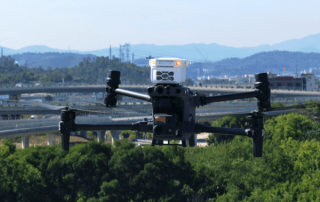
We contribute to environmental monitoring using specialized drones with sensors and cameras, conducting aerial surveys for crucial data on air quality, biodiversity, and conditions. Our solutions enhance monitoring precision and efficiency.

Drones’s benefits in the environmental monitoring field

Remote Sensing and Inaccessible Terrain

Drones access remote areas with advanced sensors, flying over forests or rugged landscapes.

Cost-Effective Data Collection

Streamlining data collection, drones save costs in environmental monitoring compared to traditional methods.

Rapid Response and Real-time Monitoring

Drones swiftly acquire data for immediate analysis and response to environmental challenges.

Minimised Environmental Impact

Using drones minimizes ground disturbance and reduces ecological footprint and environmental degradation.

Services we offer for environmental monitoring field

Monitoring Air Pollutants with Drones

Air Pollutants

Our Air Pollutants service utilizes advanced drone technology and performant gas detector systems for precise aerial surveys, delivering real-time data on air quality parameters, ensuring comprehensive insights.

Flora and Fauna Monitoring Drone

flora and fauna monitoring

With state-of-the-art drone tech, we offer unique biodiversity and ecosystem perspectives. Equipped with specialized sensors, our drones provide detailed insights into habitats, empowering conservation and ecological research efforts.

a Surveyor who makes measurements in the quarry

Mines & Quarries

Our services offer unparalleled efficiency in surveying, mapping, and monitoring. With detailed data and insights, our drones enable smarter decision-making, enhancing safety and sustainability.

Bathymetry

Our batymetry sensors provide precise underwater mapping and depth measurements. Our aerial technology offer comprehensive data collection for marine applications, ensuring accurate assessments of underwater terrain.

Our Credentials

WWF Website
Sitemark Website
La Orizont Website
Mapeo Website
Apele Romane Website
Cuprumin Website
Apa Galati Website
GeoEcoMar Website
Petrom Website
INFP Website
OMV Romania Website

News and case studies

Go to Top